|
|
|
At Railway City Tourism we often hear about the Elgin Hiking Trail. We also get asked lots of questions about the trail. Having never actually hiked it before, it's really hard to answer any questions, no matter how familiar we are with the map!
Powered by Wikiloc
Highlights
Hiking the Trail - June 12 2019
At Railway City Tourism we often hear about the Elgin Hiking Trail. We also get asked lots of questions about the trail. Having never actually hiked it before, it's really hard to answer any questions, no matter how familiar we are with the map! 
Hi! We are Megan and Sarah and we usually work behind the scenes at Railway City Tourism. On June 12 2019, we decided that we needed to live the experience so we could better answer questions for people (and also get some amazing trail photos)!
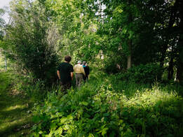
We are both amateur hikers, and it showed! Somehow we managed to pack some snacks and water, but it was more of an afterthought (please don't forget this if you do the trail). We knew that the entrance was at the Sunset Cafe (184 Sunset Drive), but that was all we knew. Thankfully, some trail club members happened to be there and showed us the way in. It's not that hard to find, it's at the southern point of the property heading into the woods, just next to the cemetery. So we entered the trail and off we went! This point was very beautiful with phlox growing and peppering the forest floor with shades of purple and white. We eventually caught up with Kettle Creek and were blown away by the sand dunes and the views! If you can't do the entire trail, we highly recommend doing this leg between the Sunset Cafe and the dunes. To make things even more picturesque, a mother deer and her fawn were at the base of the creek having a drink.
We were feeling pretty good by the time we hit John Wise Line. The trail had a been incredibly interesting as we moved from forest to fields and back again, and we had been hiking about 2 hours at this point. You have to cross the highway here, but we were back in the woods once again.
There are points on the trail where it's difficult to find the trail markers (blazes). We highly recommend loading the digital map up on your phone and following along. So far we weren't doing too bad. We continued on, had a snack, skirted some more fields, and ended up on Mellor Road. Some points of the trail do travel along roads, but there are still markers to help you navigate. At this point we'd travelled very different terrain and observed that no matter where we were, we felt like we were in the middle of nowhere. It was beautifully quiet and still, with little sign of civilization - even though we knew it wasn't far!
Things became confusing when we met up with the L&PS Rail Line. We lost some markers and had to follow the tracks until we could find the trail again. Some advice around this area is to note the trail does stay in the woods, even if there are points where it crosses the tracks. This is an operating tourist rail line so keep an eye out for trains!
You come out at Union Station, an adorable tiny train station along the L&PS. From here you join Sparta Line and continue on back roads until reentering at Union Road. These country roads have beautiful scenery, so even if you aren't back in the woods, it's still a worthwhile trek. The forest on the final leg to Port Stanley was the most challenging. The trail hugs steep hills, and this is not for the faint of heart, or young children. However, the scenery continues to evolve and stun us. There is something magical about the Carolinian forests, and it was always changing even from St. Thomas to where we were now. We were absolutely delighted when we exited the forest at Port Stanley to find the Lake Erie Salmon and Trout Club. This space was amazing! We entered at feeding time when the fish food was released and the water looked like it was boiling there was so much activity. Anyone can feed the fish, and this place is open to the public with picnic tables, native trees, and some beautiful places to sit and relax. A great place to bring the family!
That's the end of the off-road section. We followed Carlow Road into Port and on to a celebratory dinner at GT's on the beach. It was well deserved 6 hours later for us two limping ladies.
Overall we were incredibly impressed with this hike, and find that with certain sections exiting onto roads it would be easy to do a section of the trail and get a ride back. Doing the St. Thomas to Port Stanley portion was worth it, but you need to have some hiking skill and a day set aside. And thankfully, we had a ride back to St. Thomas. Elgin Hiking Trail Club
We ran into members from the trail club at the access point at the Sunset Cafe. Even though we did a long trek from St. Thomas to Port Stanley, they wanted to highlight that there are many ways for people of all skill levels to enjoy the trail. More importantly, they host many different hikes and walks throughout the year!
Keep an eye on their website for more.
0 Comments
Leave a Reply. |
AuthorHi there! We are here reporting from the L&PS Station - home of Railway City Tourism. We do our best to bring you seasonal and relevant information on what to see and do. It is not down in any map; true places never are. |