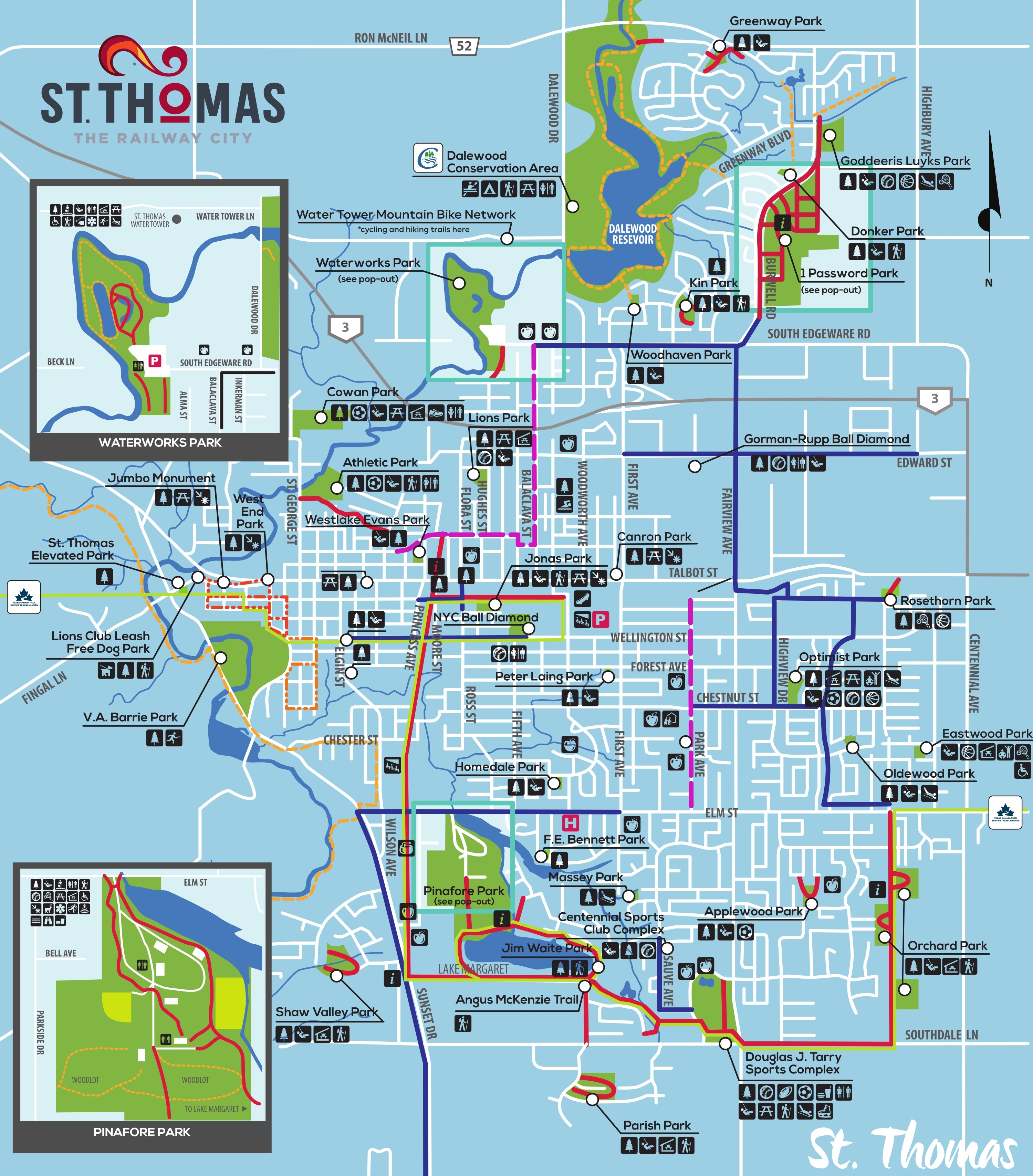
Page Builder Instructions
St. Thomas Ontario
  • Things To Do
    • Arts & Culture
    • Downtown
    • Heritage
    • Jumbo
    • Murals
    • Parks & Nature
    • Shopping
    • Gift Shop
    • Spas & Wellness
    • Sports & Recreation
    • Whistlestop Trail
  • Events
  • Food
  • Stay
  • Blog
  • Things To Do
    • Arts & Culture
    • Downtown
    • Heritage
    • Jumbo
    • Murals
    • Parks & Nature
    • Shopping
    • Gift Shop
    • Spas & Wellness
    • Sports & Recreation
    • Whistlestop Trail
  • Events
  • Food
  • Stay
  • Blog

​Trails:
​
ST. THOMAS & AREA

ride, run or roam.

Find loads of trails for all skill levels in St. Thomas and area. There's rustic hiking trails, paved bicycling trails, or even follow some historical trail roots from the comfort of your a vehicle. 
Home  /  Things To Do  /  Parks & Nature
Picture

Ride Run Roam

Take a trip down the Whistlestop Trail, from downtown St. Thomas to Port Stanley. You can walk, bike or drive between destinations. MORE
​
Picture

The Local Lens

Learn from local photographers where the best spots are to photograph and where to hike for those scenic views! MORE
​
Picture

Elgin Hiking Trail

Follow Megan and Sarah from Railway City Tourism as they hike the Elgin Hiking Trail and document the trip along the way! MORE
​

St. Thomas Trail Map

​VIEW MAP
​⮕​

​Click to download full version
Here is a tree trunk with mushrooms growing out of it. The bark of the tree is dark brown, and very cracked. The mushrooms are growing out of a mini whole in the branch. The mushrooms vary in size, but are relatively circular with small brown marks on the top. the overall colour of the mushroom body is a cream/yellow.

Area Trail MAps

st. thomas & central Elgin

  • Dalewood Conservation Trail Map​  |  Website
  • Dan Patterson Conservation Trail Map​​  |  Website
  • St. Thomas City Trails
  • Water Tower Mountain Bike Trails
  • ​Yarmouth Natural Heritage Area (Sparta)
  • Hawk Cliff  (Port Stanley)
  • ​Solitude Nature Reserve (Port Stanley)
​

aylmer

  • Aylmer Trails
  • Archie Coulter Conservation​​ | Website
  • Springwater Conservation Trails​ | Website
​

elgin county

  • Elgin Hiking Trail  | Online Version​
  • Elgin Hiking and Cycling Trail Map
​

west elgin

  • Dutton Trails
  • Fingal Trails PDF
  • Fingal Wildlife Management Area
  • John E. Pearce Trails
​

EPIC TRAILS THROUGH ST. THOMAS

Picture

The Great Trail

DEEPLY CONNECTED across Canada.

The Trans Canada Trail is the longest recreational trail in the world, and offers a wide range of activities through a variety of landscapes – urban, rural and wilderness, along greenways, waterways and roadways.
​
The Trail runs through St. Thomas with various points of interest.

➡️​ ​MORE DETAILS 

​
Picture

Talbot Trail

The Talbot Trail is historically-significant overland route completed in the 1820s. The trail extends from Windsor to Fort Erie, with sections following Highway 3. 

The building of the route was overseen by Colonel Thomas Talbot. Its original intent was to provide a continuous land route for settlers and military personnel between the Niagara region and Amherstburg, aiding in the development of the Talbot Settlement.
​
➡️ MORE DETAILS

​

It's our goal here at Railway City Tourism to find all the trails in St. Thomas and area and post maps or links. If you know of a trail that is open for public use, and not on our list, please contact us so we can include it.
Contact Us

605 Talbot Street, St. Thomas ON N5P 1C6
​
Sitemap | About | Privacy | Contact
Picture
#ExploreRailwayCity​
© 2025 Railway City Tourism 

E19823942023LUMIN283